[Print version]
Dar al-Manasir – A virtually unknown natural and cultural landscape above the 4th Cataract [Translation into English: Heinrich Hall]
Dar al-Manasir, the “Land of the Manasir”, is located circa 400 km north of the Sudanese capital, Khartoum, in a section of the Nile Valley, where the river mostly flows towards the southwest. For dozens of kilometres, the landscape is dominated by the 4th Cataract granite ledge, which outcrops to the surface here. On the river bank, it is manifested by extensive chains of hills that are hard to traverse, and in the river it forms innumerable smaller and larger islands, with eddies and rapids between them, preventing continuous shipping. Because of its location and character, the region has remained untouched by the major routes of long-distance communications since antiquity. Southbound travellers through Nubia from Egypt would either cross the Nubian Desert and rejoin the river in the area of Abu Hamed, or would leave the Nile Valley below the 4th Cataract, to cut the Great Nile Bend by crossing the Bayuda desert, regaining the Nile only above the 5th Cataract, in the area of its confluence with the Atbara river. To this day, it is not easy to get to Dar al-Mansir. The paved road ends at the dam construction site. The tracks that continue for several dozen kilometres beyond are a challenge even for off-road vehicles. The rocks often reach down to the very bank of the Nile, so that at times settlements that are located within visibility of each other on the same bank can only be reached via long detours through the desert.
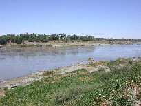 Soils that can be used to grow domesticated plants are only available in the immediate vicinity of the river. Especially on the right bank and in the downstream half of Dar al-Manasir, they are so rare that not even a continuous band of shoreline green breaks up the greyish-brown and yellow landscape. Since settlements favour higher ground, but also strive to be as near the fields as possible, they are restricted to small hamlets, rarely containing more than a dozen families.
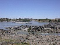 Sometimes directly by the shore, and sometimes a few hundred metres inland, there begins the desert zone, in which the human eye espies little else but rubble-covered sand, stones, rocky outcrops and the indentations of Wadis. Sporadic plants, animals and surprisingly many traces of human activity indicate, however, that even these areas are not as hostile to life as they may appear on first sight. The scarce winter rains, except in those years when they fail to occur, provide for a vegetation that offers the basis for nomadic animal husbandry. Until a few decades ago, the nomads kept large herds of camel, the owners of which usually lived on the Nile. But a sequence of several dry years led to a drastic reduction in the camel population, so that the animals are rarely seen today.
Since Dar al-Manasir represents a relatively self-sufficient cultural and economic cell, its isolation leading to some traditions surviving longer than elsewhere, it offers promising perspectives for landscape archaeological research. Such studies can throw a light on the influence of the natural landscape on human life, on how humans adapted to their environment, and how they shaped it. They also aim to elucidate the extent to which this hard-to-reach region served as a refuge for human populations from other areas at different times. Written sources tell us that during the Middle Ages, on several occasions rulers of the downstream kingdom of Makuria sought refuge behind the 4th Cataract from dynastic disputes or military attacks from the North. It is not unlikely that comparable things happened during other periods.
[Print version]